
It's been a long time since I planned a major hike like this by myself, and to say it was overwhelming is an understatement.
It was scary, and frankly, I almost canceled.
But I did it anyway. 🏔️
So for those who want to try solo hiking but are scared like me, my advice is: don't be afraid to step out of your comfort zone.
This was one of my best hikes ever, and I will never forget it. I love hiking with friends, but I'm starting to understand why some people love solo hiking too.
I picked Tateyama because I heard it's one of the best mountains to hike solo, since there are always lots of other hikers around. There were a lot of people from Murodo to Oyama, but after Oyama peak, I only saw a few.
It was scary, but I'm pretty confident using my offline maps. I've been using them for 2 years now when I hike with friends. I wouldn't recommend going here without them, because some parts of the trail after the third peak and Bessan aren't well marked.
I'm all for trying something that scares you, but I hope you still exercise caution.
If you ever do go here, I hope you enjoy it as much as I did!
📑 Table of Contents ▾ tap to open
HIKE LOG :
HIKE LOG :
Sep 23-24, 2026 / Toyama Prefecture
Tateyama 3 peaks to Bessan Peak
Start Murodo / 室堂 (2,450 m)
Summit Oyama / 雄山 (3,003 m)
Summit Onanjiyama / 大汝山 (3,015 m - the highest)
Summit Fuji-no-Oritate / 富士ノ折立 (2,999 m)
Summit Masago-dake / 真砂岳 (2,861 m)
Overnight Kuranosuke Sanso / 内蔵助山荘
Summit Bessan / 別山 (2,880 m)
Goal Mikurigaike Onsen / みくりが池温泉 (2,410 m)
Day 1 :
Time : 08:30 – 15:45 (Murodo → Kuranosuke Sanso, including breaks)
Distance : 6.68 km
Elevation Gain : 686 m
Day 2 :
Time : 07:30 – 13:30 (Kuranosuke Sanso → Mikurigaike Onsen, including breaks)
Distance : 7.93 km
Elevation Gain : 457 m
Temperature : around 8–12°C on the ridge (approx.)
YAMAP LINK : I didn't record to save battery because I lost my charger.
Difficulty : 3 out of 5
MAP

ELEVATION PROFILE
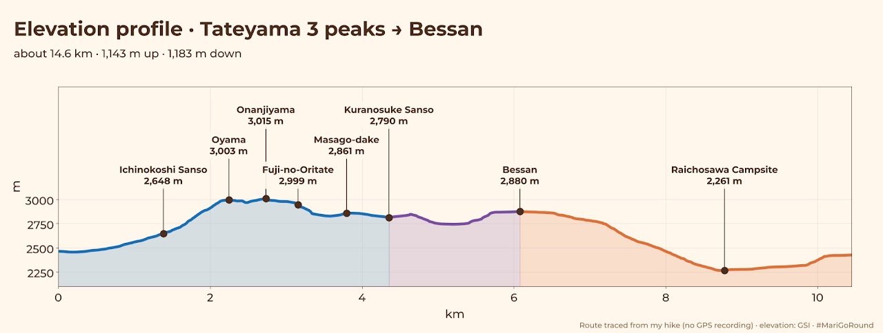
For the hike itself, use YAMAP. Download the map offline before you go.
HOW TO GET THERE
Planning how to get to Tateyama was confusing for me at first because you have to make lots of transfers, but hopefully this blog can help you plan your own Tateyama hike.
Going home, I took the Alpine Route, and it wasn't as hard as it looks.
You might need to book early during peak season.
Here's how I went home on the Alpine Route ticket (Murodo → Dentetsu-Toyama, ¥5,510 one way):
1. Highland bus: Murodo → Bijodaira 美女平
2. Tateyama Cable Car: Bijodaira → Tateyama Station 立山駅
3. Toyama Chiho Railway: Tateyama → Dentetsu-Toyama 電鉄富山
Fun fact: the cable car still pulls a cargo car in front, and before the mountain road was built, it even carried the highland buses up the mountain!
DAY 0 (Sep 22, 2026)
I took the night bus from Tokyo Station (21:40) to Murodo (arriving at 08:00 the next day). It was ¥19,000 one way.
I don't know about you, but I think night buses are just not for me. Even though it was a direct bus, and more convenient than making lots of transfers, I wasn't able to get proper rest or sleep.
Next time, I think I'll just go the night before and take local transportation.
Here's their route overview:

There are also other ways to get to Murodo by train, cable car and bus. Check the official Tateyama Kurobe Alpine Route access guide.
GEAR
Backpack : Gregory Jade 28 (28 L)
Backpack Weight : 12 kg
Water : 2 L hydration reservoir (Platypus Big Zip EVO) + 500 ml bottle of Pocari Sweat
Others : Trekking poles
TIMELINE
DAY 1 (Sep 23, 2026)
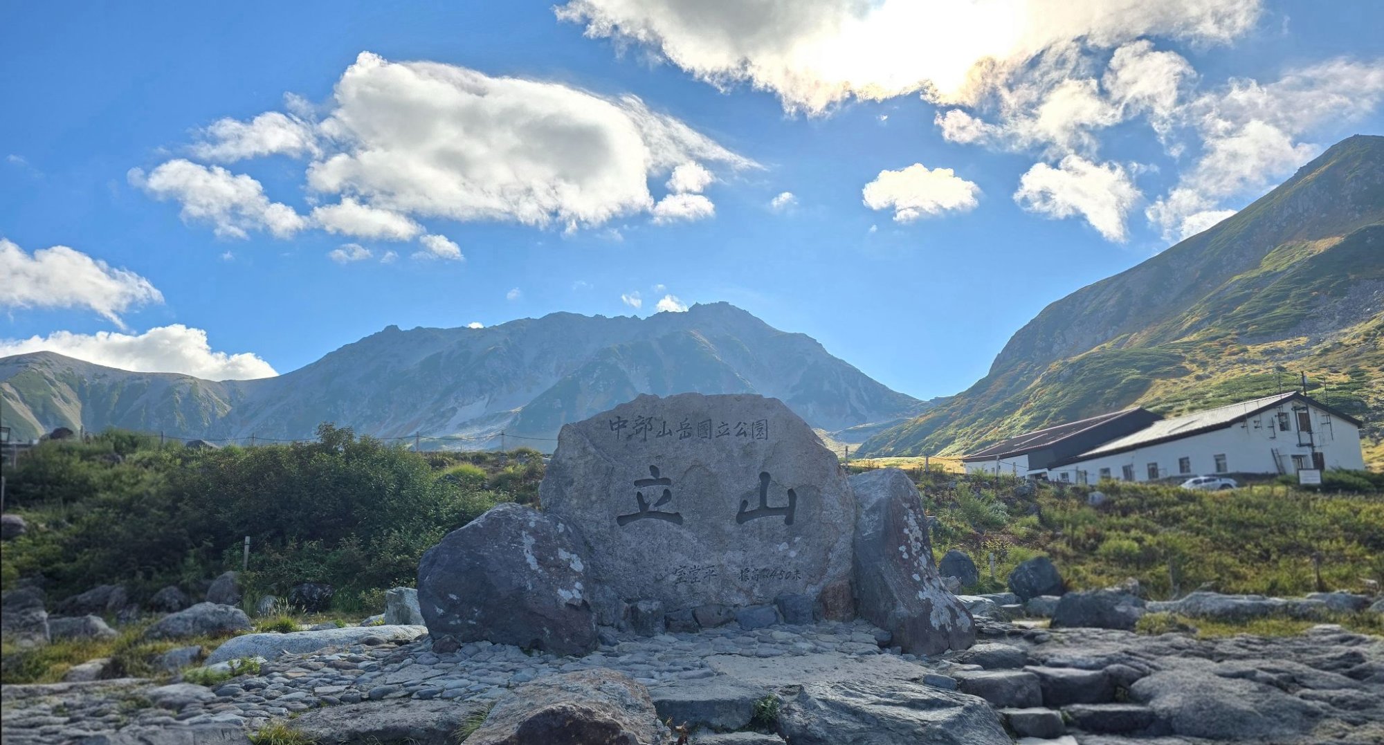
I arrived at Murodo around 08:00, went to the bathroom and got ready for my hike. I wanted to start as early as I could, but I still queued for a photo at the Tateyama landmark and didn't leave until 08:30. My plan was to go to Oyama peak via the Ichinokoshi route.

Tateyama landmark right outside Murodo station

Start of the trail.
① 08:53 – Reached Murodo Hut
Tateyama Murodo Hut stands at about 2,450 metres on the Murodo plateau in Toyama, and it is known as the oldest surviving mountain hut in Japan. For centuries Mount Tateyama was one of Japan's three sacred mountains, and pilgrims climbed it as an act of faith. Murodo was their resting place before the final climb to the summit shrine.

The oldest mountain hut in Japan
The hut we see today was rebuilt in 1726 with the support of the Kaga clan, during the Edo period when Tateyama worship was at its peak. It was built from sturdy virgin timber brought up from Bijodaira, and it kept sheltering climbers until the late 20th century. Today it is restored and designated a National Important Cultural Property, and the interior serves as a small gallery about the mountain's pilgrimage history.

You can see Oyama peak between the two huts.
The path up to Ichinokoshi Sanso was mostly cemented rocks, and there are lots of benches and places to sit and rest. I took lots of breaks on this part of the trail because, honestly, I didn't expect it to be so long. Some people told me it's super easy for beginners, so I guess I underestimated how long it would take me to go up. I was also super tired and sleepy, so it took me a while to warm up.
There were lots of people on this trail because it's a tourist area. I was never alone.
② 10:31 – Arrived at Ichinokoshi Sanso
I needed a caffeine boost, so I ordered coffee and rested here. The bathroom was clean too.

Ichinokoshi Bathroom. I forgot to take a picture of the actual hut because I was struggling to breathe!
10:45 – Left the hut and started the steep ascent
I actually liked this part for some reason. I don't know if I'd finally warmed up after that coffee or if my workouts were finally paying off, but I didn't have much trouble going up this part, despite carrying a 12 kg pack. I also loved the view on the way up!
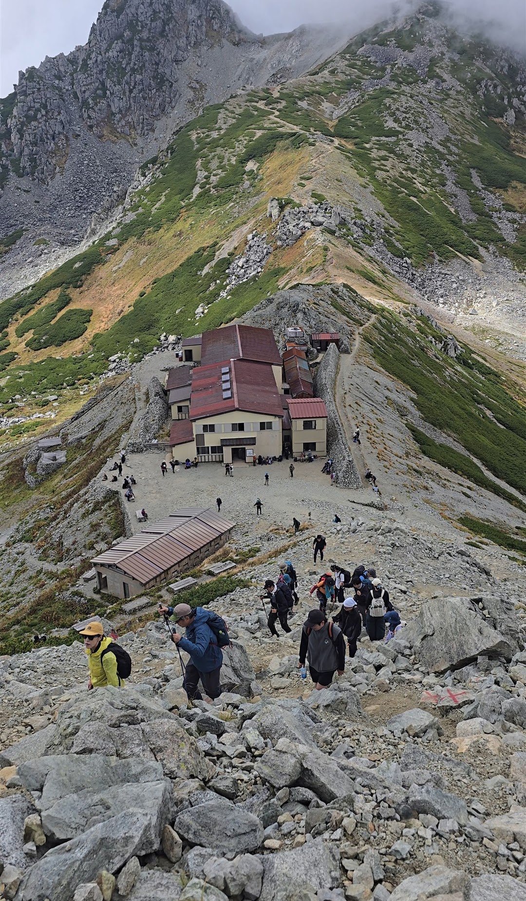
Ichinokoshi Sanso from above
③ 12:16 – Arrived at Oyama peak / 雄山 (3,003 m)
I paid ¥700 to go up to the summit shrine and join the purification ceremony. After the priest purifies the group, everyone shouts "Banzai!" three times together. It celebrates reaching the summit safely and wishes everyone a safe descent, good health and good luck.

I read somewhere that they used to give you a small cup of omiki (sacred sake) after the ceremony, but I guess that changed after COVID, because we didn't get one.
Fun fact: Oyama Shrine is actually made up of three shrines. The main one is the summit shrine (Mine-honsha / 峰本社) right on top of Oyama, and the other two are down at the foot of the mountain in Tateyama town. So to visit the main shrine, you have to climb 3,003 m!
Oyama Shrine has no main hall holding a god. The mountain itself is the god. It worships Mount Tateyama directly, which only a few major shrines in Japan do.

After the ceremony, I bought a cup ramen and had lunch here. They also sell omamori here.
13:00 – Left Oyama for the next peak
No one was going this way, so I wasn't sure I was on the right trail. I even went back to check, but the sign to Onanjiyama pointed this way.
After a few minutes, I saw some people heading back, but still no one going the same way as me. To be honest, I thought about turning back because I was getting scared. It was really foggy, and I couldn't see more than 5 meters ahead.
But I was already there, so I just kept walking.
④ 13:40 – Reached the second peak, Onanjiyama / 大汝山 (3,015 m)
The highest of the three peaks, and also the highest peak in Toyama Prefecture.

Thank you to the fellow hiker who took this picture for me!
There's a rest hut next to it where you can take a bathroom break, and it looked like they also had food and drinks, but I was starting to worry about time, so I didn't stay long.
It took me 40 minutes to get here because I kept looking around for people, waiting to see if anyone would come my way, and checking my map to make sure I was on the right trail. It was also foggy, so I was very careful with my steps. At one point I almost lost my balance and fell. But if you walk at a normal pace, it only takes about 20 minutes.
⑤ 14:20 – Finally reached the third peak, Fuji-no-Oritate / 富士ノ折立 (2,999 m)
This was the scariest part for me because it's a rocky peak without any markings. I saw an elderly couple coming down just as I was about to go up. I wished I'd gotten there earlier so I could have followed the way they climbed, but no, I was completely alone at that point.
I left my pack at the bottom and started climbing, but I really couldn't figure out which way to go. I almost gave up and went back down, but I didn't want to regret it later. I shouted to the couple and asked how they'd climbed up, and they were sooooo nice and guided me. They even stayed a little while to make sure I made it, because I saw them when I reached the peak. It definitely felt like my grandparents were looking out for me.
I just LOVE Japanese hikers. They're so respectful and kind. They encourage you when you're dying on the trail. Some even hand out chocolates or candies and say "Ganbare!" I just love the hiking culture here.
After reaching the peak, I looked for the summit marker but couldn't find it. I gave up, thinking maybe it had blown away in the recent typhoon. Later, other hikers told me it was between the big rocks. So I guess I'll be going back next year for a revenge hike!
14:30 – Back down, grabbed my pack and headed to the next peak (yes, another one!)
From here on, I relied completely on my offline map (YAMAP) because the trail isn't well marked. It was also foggy, so it was hard to see where I was heading.

I finally saw a couple heading the same way and asked where they were going, hoping it was the same hut, but they were going somewhere else. I was still happy, though, because I had company, even for a little while.

The fog (Japanese hikers call it "gas" / ガス) cleared for a few minutes, and I was able to appreciate the hike more. This ridge was so pretty. You can see the Raichosawa Valley and Mikurigaike (where I'd be staying on the second and third nights).
⑥ 15:32 – Reached Masago-dake / 真砂岳 (2,861 m)
There's old ice below this part. I couldn't see it because of the fog, but on the east side is the Kuranosuke Cirque (内蔵助カール), home to the Kuranosuke Glacier (内蔵助氷河, Kuranosuke Hyōga), which has a permanent snowfield.
Beneath the snow is a permanent body of ice, about 30 m thick, that never fully melts, even in summer. That's why it counts as a glacier and not just a seasonal snow patch. The oldest layer, at the very bottom, is estimated to be about 1,700 years old and is thought to be the oldest ice in Japan. That means it formed around the 3rd–4th century, roughly the time of Himiko and the early Kofun period.
Hopefully I'll be able to see it properly next time! I wonder if you can go down and see it? Let me know if you've done it!
⑦ 15:45 – I FINALLY REACHED MY HUT
Kuranosuke Sanso (2,790 m) is a family-run hut with a homey feel. It's known for having one of the best sunrise views in Tateyama because nothing blocks the view to the east.
I want to stay here again the next time I hike Tateyama, because I really loved their food. It was the best hut meal I've ever had in Japan! For those who aren't familiar, most hut meals are just curry rice, so we were really surprised by what they prepared for us.
I also met Chizuru-san. What are the chances I'd meet someone who was on the same route as me, hiking solo too, and staying at the same place on the second night as well? Because of her, my second day of hiking wasn't as scary as the first. Thank you, Chizuru-san! Looking forward to more hikes with you.
MOUNTAIN ACCOMMODATION
I chose this hut because I wanted a moment to reflect on what was going on in my life while watching the sun set and rise, but unfortunately, the weather didn't cooperate. But guess what? As we were talking about it, the sky turned pink for a little bit and gave us a gift.
It was so quick that it was over before I was able to take a picture. But it's okay, not everything is meant to be photographed.
It was very short but meaningful for me, because I felt like God was telling me that even though I have plans for myself, His plans will always be a million times better. I also think He was teaching me to be okay with the things I cannot control, because some things in life really are beyond our control.
So I wasn't disappointed about not getting the best sunset on this hike, because I learned a lesson far better than that and gained something bigger than what I had planned for myself. I felt an immense sense of gratitude for life itself, something I had been questioning for the past few weeks…
…and I think I found the answer on this trip :)
Thank you, as always, for following my adventures!
Watch the videos on YouTube @marigoroundofficial and say hi on Instagram @marigoroundofficial.
EAT, SLEEP, HIKE, REPEAT =)
#MariGoRound